So we met up with our friends in Ardrishaig Basin at the end of the Crinan Canal. They have been going clockwise in their large steel yacht, Friars Goose, while we have been going anticlockwise.
Onshore we live within a mile of each other.
It feels strange in some ways to have this reminder of home and normal life, afloat is our new normal.
From here we are back on the sea all the way home.
The basin is quite small, and was packed with boats, but at least you can still see some water. John told us of being in Oostende, when you could walk from side to side without getting your feet wet.
56 00.731' N 05 26.809' W
Thursday, 29 July 2010
Wednesday, 28 July 2010
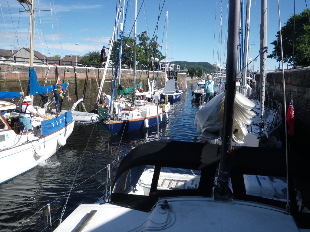
The Crinan at last!
Having had a good night's sleep, we left for another attempt at the Crinan Canal. The weather was fine and clear, and ,by timing our passage well, going through the tidal race at Dorus Mor was fairly straightforward.
The entrance to the canal was in sight.
Unlike the Caledonian Canal, appart from the sea locks and swing bridges, you have to operate the locks yourselves. With just two onboard this can be tricky, but we were lucky enough to meet other boat crews to share the work with. Again though, there are insufficient mooring places along the canal, for the number of boats passing through. The scenery is beautiful, and the whitepainted lockkeepers cottages are delightful.
Still, we reached the half way point before stopping and rafting up with two very pleasant families ready to continue in the morning.
56 03.627' N 05 28.979' W
Tuesday, 27 July 2010
Dash it chaps and other similar phrases
There we were, in the Sound of Luing, zooming along in the tidal stream at 10 knots when there was an awful bang from the engine compartment and the engine revs dropped right off. Not a good place for this to happen. Robin looked inside and a bolt holding on the alternator had sheered off, meaning we also had no coolant on the engine.
Using his tool box and draining the hot water tank, Robin did an emergency repair that allowed us to motor slowly to safety, but instead of Crinan Canal, we had to look for a destination that avoided any more tidal races. Luckily we found one on Loch Shuna called Croabh Marina - ideal! Radioed the coastguard of our situation, and were asked for half hourly updates until we reached safety.
As we approached Croabh , another yacht approached, which had heard our radio conversation with the coast guard and had diverted to see if we needed any help, or a tow into the marina. Thankfully we were able to get in under our own power, but I didn't get the boat's name, so if you ever read this, thank you whoever you are.
The marina is well equipped and in a pleasant spot, so Robin was able to get a bolt which should last us until we get home and have time for a more permanent fix. It meant lifting the engine off its mount, but what else are booms for?
Job done, we both went for a hot shower and met up with some people we knew for a meal at the hotel onshore. OH2, the motor yacht we first encountered at Amble, then Peterhead, was also at Croabh.
56 12.723' N 05 33.477' W
Sunday, 25 July 2010
Serendipity
We left the Sound of Shuna early to catch the tide and went down the coast passed Oban. Once in the Firth of Lorn and Kerrara Sound (aren't the names very evocative?) we moored up in Horseshoe Bay to take a break and plan the next stages of our journey. The West Coast of the Mull of Kintyre has a tendency to be a rough trip, so we were considering using the Crinan Canal as a short cut through to Loch Fyne.
Unlike the Caledonian, in the Crinan Canal you have to work the locks yourself, so we were in two minds about being able to manage it. Really you need a crew of three or four. Suddenly Robin's phone rang. It was some friends of ours who were doing the clockwise version of our journey. They were at the Crinan Canal, wanting to get through the other way! Unfortunately Christine has hurt her leg, so Robin and John came to an agreement to help each other through the locks. The Crinan is on then.
Meanwhile we took the opportunity to rest up fully and do some tide checking. Kerrera Sound is fascinating to watch. The commercial traffic tends to go out the north end, so here we see small racing skiffs zooming across the water from side to side of the channel. Plus seaplanes land on the water near Oban, so we could watch them fly overhead.
After a break, we motored a few miles down Inish Sound to an anchorage at the south end of Seil Island for the night, in a small stretch of water between Easdale and Ellanbeich.
56 17.674' N 05 39.175' W
Saturday, 24 July 2010
On the West Coast
A busy day alround. The swing bridge was fixed, and so we were able to leave Gairlochy at 8am. Neptunes Staircase, a flight of 8 locks awaited. We arrived at 10am, to find the people coming up were still in the locks, and we finally started the long descent at about 1030.
Going down is less hard work than coming up, but not without its adrenaline rushes. You have a line running from the front and back of the boat, each wrapped around a hook on the lockside, which you release gradually as the water level drops. In the third lock the stern rope jammed, leaving the boat hanging from the lock wall. Robin grabbed a knife and cut the rope before any damage could be done. He then had to throw a new rope to one of the lockkeepers to stop Catabout drifting across the lock into the boat on the other side.
After a stop to refuel and top up the water tanks, we eventually left the canal and back to thinking about tides again at 4:00pm, heading down Loch Linnhe for the Corran Narrows. Here the land "pinches" the movement of water in the Loch, so that the water can run at 6 knots - you want it to be going in your direction! There is also a ferry that links the two sides at this point, so we had to time our run through the narrows with the ferry's sailings.
Once through, the Loch opened out again, but sadly we didn't get the full benefit of the views, as the weather closed right in. Got to the Sound of Shuna and moored for the night. What a day.
56 34.947' N 05 22.862' W
Friday, 23 July 2010
Canal Frustrations
Got through the staircase at Fort Augustus by 11:45, so we pressed on in the fine weather, going up the remaining locks to Loch Oich. There were a few noteworthy landmarks on the loch shores; The Well of Seven Heads (the more gory-minded of you, click on the link for the story behind the name) and the ruins of Invergarry Castle.
After Loch Oich it is down hill all the way, as the locks gradually bring us back to sea level. At the western end of Loch Lochy we caught up with the fast boats who left us behind earlier in the day, as the swing bridge at Gairlochy is not working. I hope it can open tomorrow. Meanwhile the location is stunning, in the shadow of Ben Nevis, it is sunny and we are doing the laundry at last.
Ben Nevis is stunning, and you can see the snow remaining in the valleys near the summit. An added bonus is that you can actually see the summit, as it is usually wreathed in clouds.
View Larger Map
56 54.873' N 04 59.548' W
Thursday, 22 July 2010
Fort Augustus

Fort Augustus is a real tourist town at the south western end of Loch Ness. There are souvenir shops and boat tours on the lake. The original Fort Augustus, part of the chain of forts used to keep the highlanders in check after the Battle of Culloden, was coverted to a Benedictine Abbey in 1876. The Abbey was finally dissolved in 1998, when the building passed into private hands.
Because of it's position, it is a gateway to the highlands for many holidaymakers. For us it was the end of a gentle day's sailing and motoring down Loch Ness, enjoying the scenery bathed in sunlight, so different from yesterday. We passed close to the iconic Urquhart Castle, that appears in many a photo album of the area. There were very few boats on the loch: a couple of yachts and a handful of motorcruisers. At times it felt like we had the place to ourselves.
On arrival, all boats using the Caledonian Canal are required to moor at one of the pontoons, and go to see the lockkeeper about potential locking in times for the staircase leading to Loch Oich. We arrived at 3pm, and were unable to get a time, other than it would be sometime before the locks closed for the night.
One of the good things about the spot is that it has one of the British Waterways Users laundry facilities. We've been afloat three weeks, so use your imagination!
Then the bad news: the washing machine just broke down as a german couple were using it and we can't get through the lock tonight. Oh well. At least it's a nice spot.
57 08.777' N 04 40.550' W
Wednesday, 21 July 2010
A Day of Rest 2

The weather is not good today and the views going down Loch Ness are not to be missed, so we have opted to have a rest day today and are stopping here in Dores bay for a break.
It is nice and cosy in the boat with the sound of rain on the coachroof above our heads. I've taken the time to add some photos to past posts, so go have a look.
Tuesday, 20 July 2010
Desparately seeking Nessie
I felt I had to share with you our encounter with one of life's true individuals here on the beach at Dores. This trip is all about living the dream, not just dreaming it, and the man we met was also living his dream.
Steve Feltham lives a converted mobile library van on the beach at Dores, and is a full time Nessie hunter. Inspired by a childhood encounter whilst on holiday with his family in Scotland, in 1991 he sold his house in Dorset, in the south of England, and moved to the Loch to pursue his dream to find the Loch Ness creatures.
You can find out more about him on his website, or on his Facebook fan site.
Fresh Water Sailing

The sea lock opened for us at about 0750 this morning, and we moored on the canal at
Dochgarroch, taking a breather before the final lock before entering Loch Ness itself. The name canal is a misnomer, as the bulk of the journey is through four lochs in the Great Glen:Loch Lochy, Loch Oich, Loch Ness and Loch Dochfour. The canal sections has 29 locks, to raise and lower the boats up to 32m above sea level.
On this stretch, we encountered our first simple locks, swing bridges and staircase, where the top gate of one lock is the bottom gate of the next. Locks are hard work, even when the lock gates and sluices are operated for you by the British Waterways staff.
Each "locking" contains as many boats as possible, to maximise throughput and minimise loss of water. Our first experience contained eight boats, including ourselves. There we met up with another of the boats who had been stuck with us at Peterhead, plus a nice swedish couple who were off around the world. Scotland was their first experience of dealing with tides.
After Dochgarroch, we motored gently through the loch, passed Dochgarroch House and Aldourie Castle into Loch Ness. We have anchored just off Dores and are off to the pub.
57 22.931' N 04 20.180' W
Monday, 19 July 2010
Inverness bound

Off again today, making further way towards Inverness and the entrance to the Caledonian Canal. This goes down the Great Glen, via Loch Ness, coming out on the west coast of Scotland near Oban.
The winds were very light, so we motor-sailed to Inverness, passing many evocatively named places along the way: Portknockie, Lossiemouth, Findhorn, Munlochy...
There were many seabirds along the coast, and some off-shore in large gatherings, which we assume indicated shoals of fish below the surface. I wanted very much to see seals and dolphins on the way, but it took until the entrance to Inverness Firth before we saw any.
As we were motor-sailing, I took the opportunity to do my party piece - bake fresh bread on board. While the bread rolls were rising, I also made half a dozen blueberry muffins to have with a drink of hot chocolate during the passage.
The approach to the Caledonian Canal is very scenic. While the eastern side of the Firth is more developed, the western side is more mountainous, with small villages on the shoreline, backed by steeply wooded hillsides. It could very easily be an alpine lakeside.
At Inverness itself we came under the spectacular Kessock Bridge. Because we came through at the top of the tide, it was quite easy; but on the ebb spring tides, and after heavy rains, the combination of tidalflow plus the rivers that feed this area can give a flow of over 6 knots under the bridge.
So we are moored up at the Clachnaharry sea lock, waiting for it to open at 8am tomorrow morning. We then have 8 days to traverse the length of the Canal. No tidal calculations for 8 days!
So far we have passed both the most easterly and most northerly points in our journey. South and west await.
57 29.446' N 04 15.818' W 533 miles done, just under 1/3 of the way.
Ever onward
We woke early yesterday, and had a chance to view our surroundings before heading off for the day. There were a few houses on the slopes down into the bay; traditional ones being side on to the sea, presenting the minimum face to the winter gales, and the more modern ones, looking out over the sea. The bay itself was quite stunning, with a number of rock arches carved by the action of the sea on the rocky shore, one large one, and a number of small ones.

The cliffs were home to huge numbers of seabirds. I'm not well up on bird spotting, so I'm afraid I can't tell you which types, but they were quite a sight, wheeling in the air.
Weighed anchor at 9am to catch the tide. Initially, although grey and overcast, the winds were 18knots and favourable, so we made good progress. Along the coast we were passed by Tico, a large motor sailing boat that we had seen at Peterhead.
However, later in the day the wind moved round so that it was blowing almost directly from the direction we wished to head, not good for a sailing boat, and became very squally, dropping to almost nothing, then surging to 25+ knots. This becomes very tiring very quickly when sailing short handed like us (fine if you have a large crew) so we called it a day and headed in to Cullen Bay to anchor for the night.
I don't know what was going on in the town, but the sound of bagpipes swirled out across the water to greet us as we came in close to anchor. Very atmospheric.
57 42.005'N 02 49.622'W
Saturday, 17 July 2010
Off at last.
Finally made it out of the harbour and under way today. We had to wait for a cruiseliner, the SAGA Pearl, to come in before we could leave, but then we were off.
The waves were a bit rough coming out of the harbour, but once we were well clear and turned north, the rollers were following us and much more comfortable. Rattray Head was not as bad as expected, but now we've turned the corner and are heading for Inverness.
At the moment we are anchored in Fraserburgh Bay waiting for the tide to turn in our favour again. For the more technically minded, who wish to follow our progress closely, see Ship AIS. (www.ShipAIS.com)
Unfortunately, the wind continued to blow directly from the direction we wanted to travel in, so even tacking non-stop haven't made a huge amount of progress and are anchored in Aberdour Bay for the night.
57 40.790'N 02 11.145'W
Friday, 16 July 2010
Well, we're still here.
There's quite a sense of community building up between the different boat crews trapped here by the weather. We were joined last night by another dutch boat.
No need to consult the weather reports and forecasts today to see if it's fit to go out. In Peterhead Bay, ie inside the breakwaters, are rollers that wouldn't look out of place on a north Cornwall beach, or anywhere else that surfers eye, looking for the perfect wave.
Outside the breakwaters the waves are an average 2.5-4 metres in height. An average two storey house is 5 metres to the eaves.
So another day in port then.
Thursday, 15 July 2010
Convoy!
There's now six boats at least sitting in the marina here, waiting for that elusive gap in the weather. A young swedish couple, a dutch couple, a belgian pair and three british crews that we know of. A pair of german guys in a very racy looking boat made it out last night, but they were heading south.
Every so often there is a huddle around the marina office notice board, as the latest local weather forecast, supplied by the port authority goes up, and drooping heads as we realise, not yet.
The fishing crews round about us think a couple more days of serious swells then it should be ok.
Sailing is both a very enjoyable, very relaxing way of spending time and extremely frustrating.
You have no control over the wind and waves, and it is a very salutory lesson that there is much in this life we cannot dictate.
Wednesday, 14 July 2010
Stages of Seasickness

The jokey version is :
1. You're afraid you are going to be sick
2. You're afraid you are going to die
3. You're afraid you are not going to die.
For most sailors :
1. You become aware of your stomach
2. You become aware of your throat
3. You start to burp
4. You are sick
5.You get your sealegs.
Many famous mariners have been troubled by seasickness, including Nelson. Everyone who goes to sea reaches one stage or another, the lucky ones going straight to stage 5 and stay there.
This morning we tried to go out to get round Rattray Head. The tides here seem to have a life of their own, not as shown in the Almanac, so we asked the Harbourmaster for local information.
We had until 10am to have the ebb tide flowing south to north to sweep us up and around Rattray Head.
So we tried going out at 7am. Once outside the breakwater the sea was rough and confused and the fog closed in. With the prospect of another 2-3 hours of this and I was at stage 2 and contemplating stage 3 we opted to head back to Peterhead. Robin made a good job of getting Catabout back in, so much so the Harbourmaster radioed "welldone".
I didn't think Peterhead would be a welcome sight, but it was today.
Oh well. Maybe later.
The picture is a snapshot from the Peterhead webcam:
http://www.aberdeenshire.gov.uk/webcams/peterhead.asp
Catabout is extreme left at the front as you look at it.
Best laid plans and all that.
Quarter past six and the wind is still up, and rollers are making their way into the harbour, passed the breakwaters. This was not in the plan.
Robin went for a walk to the outer sea walls and saw big rollers and rough seas north of here.
So detailed review of the weather forecasts, tide tables, tidal stream atlases, wind and wave predictions to see if we've got to tough it out, or if there is a better window in the weather.
So it looks like daybreak tomorrow off and round Rattray Head and into the Moray Firth, where conditions should ease. Got to go tomorrow, because Friday onwards sees gales and stormy seas.
Don't want to emulate a friend of ours who was stuck here a fortnight.
Perhaps I shouldn't have watched the tv series Trawlermen before our holiday.
Postscript: the fishing boat berthed near us in the marina just came in, having never made it outside the main breakwaters because of the rough seas. Nice to have your decisions confirmed, because if a fisherman doesn't fish, he doesn't earn. But then he talked about 2 metre rollers tomorrow morning too.
As they are easterly, it's not too bad once we've rounded the corner, but there's still at least 6 miles due north to go, with the rollers coming at us side on.......
Amazing what a good sleep does
In order to catch the tide going our way we either had to leave at 5 in the morning or 5 in the evening. We have opted for the evening tide and are using today to catch up on jobs on the boat.
A damn good tidy and a hoover by me. Not every yacht has a vacuum cleaner on board! Making use of being connected to mains electricity via shore power. Also got rid of our rubbish. Being in port is good for that too. Sailing does make you much more aware of the waste you generate. We have a can crusher, which at least reduces the volume.
Robin has put the old VHF radio back in, as the DSC radio has developed a fault in the audio: reception is fine, but very, very quiet. Until he gets a chance to investigate further, we will use the old radio. Sometimes being a hoarder is a good thing.
Plus the leg steering arm snapped just as we came into the marina last night. Turns out there was a knot hidden in the wood. Again Robin has been able to fix it. Good job our ship's engineer is so capable.
Tuesday, 13 July 2010
Peterhead

A further 130 miles north, here in Scotland after a long offshore sail in a straight line from Northumberland. There were spells where we saw no land. It must have been hard in the days before GPS, where the crew had to take the skipper's word for it that there is more land out there somewhere ahead.
It took us 30 hours non-stop, plus the 5 hours I slept immediately on arrival. Sadly the wind dropped away to nothing overnight, so we had to motor quite a bit of the way. Both of us are very tired.
The sea is still full of jellyfish. What eats jellyfish? We saw a few seals, lots of puffins, terns and other sea birds. It is amazing how far from land they operate. The sun barely slipped below the horizon last night. It went just dark enough for the stars to be visible, and to see a meteor fall, but the sunset light in the sky just slipped around the horizon towards the north east before the sun rose again.
57 29.81'N 01 46.42'W 455 miles done (1/4 of the way)
Sunday, 11 July 2010
36 Knot winds
You know it's bad when you see the fishing boats running for harbour.
I asked one what the weather was like out there and he said wild. It has to be bad for a fisherman to say wild. Still don't see them wearing lifejackets though. Our instruments are registering 35 and 36 knot winds here in the relatively sheltered marina, so the lord only knows what it is like out there!
25 knots is getting near the edge of my comfort zone, so looks like we may be here another 24 hours. The forecast says the winds are dropping later, but I'm not holding my breath.
Update 16:00. The wind is finally easing, so we are off tonight, hoping to make the long passage to Peterhead. More anon.
Saturday, 10 July 2010
A Day of Rest
As Amble is a pleasant place, with all the facilities we need, and last week's mileage was good, we opted to make today a rest day, and stay another night.
That's not to say we did nothing. There were jobs to be done on the boat too. Sailing is not all glamour.
So this morning was a lie in , 8am! Then pump out the muck from the bottom of the diesel tank, and top up with fresh diesel. Pumping is done by hand using a scaled down version of the 1920s fireman's stirrup pump. one person operates the pump (me) while the other probes the bottom of the tank with a long probe on the inlet tube. The outlet goes to a waste oil container.
Robin was a bit miffed that I took an extra couple of minutes to put on shorts for the pumping out, but understood why when my legs got covered in diesel and gunk by the end of the operation. But it was done, and I went off for a loooong warm shower in the marina toilet block.
We can shower on board, but as we carry all our fresh water with us, they have to be short. Long showers are a luxury.
Then came the fun part of the day. We took the local bus from Amble town square to Warkworth village, to see the castle. The route followed the river bank as it wound down the valley, giving time to see the large number of swans on the water, and the sheep-filled fields. Warkworth itself is very pretty, a cross between hilly Peak District and golden stone, flower filled Cotswolds. The castle was well worth a visit, being the setting of several scenes of Shakespeare's Henry IV plays.
Lunch in the Hermitage Inn, one of Warkworth's many watering holes. I had King Scallops, one of Robin's favourites, but he was put off because they were served with black pudding, opting for fish pie instead.
Back to the boat on the bus, and I had an afternoon nap. When I woke we worked on greasing the steering leg and topped up the water. The galley was topped up from the stores and fresh milk and bread from the town.
The skipper of the boat that ran pleasure trips out to the RSPB bird reserve on Coquet Island, met us on the pontoon and said that the strong winds of yesterday afternoon had still been blowing today. This evening saw a heavy rainstorm. Quite cosy nestled up in our floating home while the rain drums on the roof. Saves cleaning the decks too.
Friday, 9 July 2010
Ambling along
Here we are at our next stop, Amble Marina, in Northumberland. Amble is a working fishing town on the mouth of the Coquet River, with the more picturesque Warkworth village and castle a little further upriver. It is possible to see the castle from our berth.
Getting in here was a bit traumatic. Having had a day of light winds of variable direction, strong winds of 25+ knots came almost out of nowhere as we approached the island at the mouth of the river. This meant that we had to get the sails down fast and the engine on, to avoid getting blown onto the rocks. At the same time we encountered a fishing boat laying his salmon nets, who was waving frantically at us, to stop us becoming caught up in them.
An adrenaline surge later and a bit of shouting and swearing, we made it safely into the marina, where two of the staff helped us tie up to the end of A pontoon.
Everyone here is very chatty and friendly, and made us very welcome. We plan to have a look at the castle tomorrow afternoon, and then make the short sail to Holy Island.
55 20.2'N 01 35.0'W 324 miles sailed.
Lazy Vince
It's one of the many nautical weather sayings that the wind gets up and goes to sleep with the sun.
Well, not today. The sun's been up for 2 hours and Vince is still asleep. Not so much sailing as tiding with style.
Frustrating as well because a couple of the main sail cars (the bits than run up the track in the mast) broke, and we have to have a couple of reefs in to shorten the sail until we can get some replacements. All the spares we have on this boat, and no mainsail cars.
Update on the broken cars, the bits were still in the mainsail track, so Robin was able to do a repair. Still need some new ones, but at least we can get the mainsail all the way up.
By the way, there could be a prize in it for the first person to identify the Vince reference correctly.
Thursday, 8 July 2010
A sailing day
Wake up 5am
Grab a quick breakfast and get dressed.
Check the latest weather forecast is ok.
Then go through the "ready to sail" routine:
Chart, pilot book, hand held radio and gps to cockpit.
Winches to cockpit.
Instruments on.
Electronic charting on.
All non-essential electricals off.
Close hatches.
Secure loose items.
Life jackets and MOBis on.
Disconnect shore power.
Remove all mooring warps except one fore and aft ready to slip (pull through cleats on shore)
Steering leg down and locked.
Engine on, into reverse, slip our lines and we're off. 0550am
Radio our daily check to the coast guard. Take the fenders in and back to the cockpit ready for sails up and engine off.
0615 and we're sailing up the coast, eating up more miles.
Talking of eating, food onboard takes on major significance. During the sail we tend to have anything that can be eaten with one hand (scotch eggs are a favourite) or drunk from a cup, in small quantities every couple of hours or so. We describe it as "Hobbit eating" - first breakfast, second breakfast, etc. Then in the evening, once we've moored or anchored up, I'll do a proper hot meal in the oven. I also run a 'treats locker'. Morale on a 3am watch is kept up by a little something special.
Tonight we literally tied up, in Sunderland harbour. We had hoped to go into the marina, but when we arrived it was apparent that we wouldn't fit. A radio call to the Harbourmaster and we are secured to one of the harbour walls. As we arrived at low tide, our lines are definitely' up', as we have to allow for the rising water level as the tide comes in.
Tomorrow is another day.
54 54.865' N 01 21.847' W
Wednesday, 7 July 2010
Nautical miscellany

For those that have asked what the numbers mean at the end of my posts now we are under way, they give our position in latitude and longitude. You can use these numbers to "see" exactly where we are using Google Earth.
51 51.60'N
gives our latitude and means that we are 51 degrees north of the equator (if you take the angle from the centre of the earth) plus 51 decimal 60 minutes. There are 60 minutes in each degree.
One minute equals one sea mile. This means that the length of a sea mile varies according to how far south or north of the equator you are. For most practical purposes one sea mile equals the internationally agreed nautical mile of 1852 metres. Prior to this agreement in 1929, different countries had slightly different definitions.
00 09.767'W
gives our longitude and indicates that we are west of the Greenwich Meridian by 9 decimal 767 minutes. The calculation of longitude was a struggle for centuries and involved many great scientific minds. Amerigo Vespucci on his trips to the New World was perhaps the first to profer a workable solution, by noting the time difference between observed happenings in the sky, eg planet movements, and times listed in an almanac for home. But it was not until the development of an accurate ship's chronometer by John Harrison, an english clockmaker, that position could be accurately determined.
The story is a fascinating one and worth spending some time looking into.
No doubt there will be more stuff as we encounter more days where the weather keeps us in port.
Tuesday, 6 July 2010
Isn't technology wonderful
Robin thought he ought to share details of a call to Number 1 son , who lives in Hong Kong:
I called Caz in Hong Kong on Monday around midday.
I mentioned that I was in the catamaran anchored in Bridlington, next to Flamborough head.
'So how are you talking to me now?' he asked.
WELL
- I'm talking into the microphone which had an A-D converter in so as to pass a digital signal through the USB into the Laptop
- There Windows XP passes the data to the Skype software which, no doubt converts the data through some grade of CODEC
- The data the goes through the 54G protocol to the Wi-Fi router (So that Sue can surf at the same time)
- Then the router is connected to the 3 mobile phone network
- Which in turn connects to the internet
- The internet transports the data to HK
- Your Laptop reverses the CODEC and, hey presto, we have a chat.
Well if you ask a data handling architect a stupid question.....................
Cas was a bit bemused by the onboard WiFi- he's in the land of the technocrats and he can't be arsed with WiFi.
It was good to talk with my favourite son. Must do that more often.
Thoughts on Lobsters


Here we are, first landfall, the Old Harbour at Scarborough. It is quite picturesque, with the seaside resort alongside the working fishdock, fishmarket and fishing boats. The harbourmaster's office is in the old lighthouse at the harbour entrance.
The victorian Grand Hotel on the seafront is just that, very grand. An open top bus runs tours around the town, and a ruined castle sits on a hilltop overlooking the bay. Time to get our landlegs back, if only briefly.
Managed to pick up cruising charts to cover up to Fifeness in Scotland. Upto now we've only been able to get charts to Whitby. It seems that no-one wants to go further north, except mad circumnavigators like us.
Scarborough sea front shops were very much as expected, but not without a charm of it's own. Icecream, fish and chips, tea shops, rock, mostly tacky souvenirs and penny arcades. Plus fresh seafood stalls offering in-between meals "ooh, go on then" portions to enjoy as you take in the fresh salt air.
As for the thoughts on lobsters, the relatively shallow coastal waters are dotted with pot markers, indicating a fisherman's lobster pots below. And the harbour side was piled with pots waiting to go out again. Now this has been going on for a few hundred years, certainly many lobster and crab generations, but they must still fall for the trick; an entrance that lets them in, but not out again. Robin and I wondered if eventually a breed of lobster and crab would develop that avoided these traps. After all, it's only the ones who get left behind that go on to breed.
54 16.98'N 00 23.35'W, 201 nautical miles so far
Passage planning
Well, we were planning to go to Whitby, but overslept this morning, and as you can only get to the moorings via a swing bridge that opens two hours before and after high tide, and the wind is still very much from the northwest, unless we motored all the way, we wouldn't get there in time.
It is frustrating when getting up at 5am and it's too late. Joys of sailing, huh. We needed that extra little bit of time to have the tide sweeping us up the coast and for the wind to have come round a bit, so it wasn't blowing from the direction we wanted to travel in. Catabout will only sail at about 45 degrees to the wind, or we have to tack (take a zigzig course), which takes a lot longer to get where you are going.
So it looks like Scarborough tonight, then, weather permitting, on to somewhere like Hartlepool tomorrow.
Will post more when we anchor or moor up tonight.
54 14.682 'N 00 09.767'w
Monday, 5 July 2010
Out cold in Bridlington
Flamborough Head
Bridlington
We've made it to Bridlington, a holiday town on the Yorkshire coast, curled up in the lee of Flamborough Head.
To get here, we sailed around East Anglia, our usual sailing grounds, across the Wash, up the Lincolnshire coast to what used to be known as the South Riding of Yorkshire. There was a bit of bad weather as we crossed the Wash, so Robin has decided we are definitley commited to this Round Britain thing - he couldn't face the Wash again this year.
Sailing at night is pretty magical, especially once you are out of sight of land. Seeing the sun set and rise over open water, when you can't see another human being, just a few seabirds taking flight. The peace and quiet of sailing along, with just the sounds of the water on your boat and the occasional flap of your sails.
Passing through busy shipping lanes can also be a challenge. There are all sorts of rules about who can go where and who gives way to whom. From overhead it must look like a slow-motion ballet or a chess game.
Just like train spotters, there are whole websites dedicated to those facinated by ships and shipping. The introduction of a new system called AIS, which logs the position and speed of every vessel over a certain size, has fed the boom. Here's a sample.
Signing off for sleep, now.
54 5.340'N 0 9.632'W
Saturday, 3 July 2010
We're off!
As I write we are passing Walton-on-the-Naze pier, heading up the coast of England, next port Whitby, home of Captain Cook and inspiration for the Dracula stories.
We set off from Tollesbury at the height of the tide at 4:30am this morning. The falling tide will then help sweep us up the coast for the first part of our journey.
Both Robin and I have been able to have a nap. We have a MOBI device from NASA Marine which alarms (VERY loudly) should the one on deck fall overboard. Each of us wears a fob on our lifejackets which links to the central unit in the saloon. A simple wireless doorbell chime also wakes the other up if they are needed on deck. A radio call to the coast guard each day notifies them of our progress.
The weather is good, the winds fair and sails up.
So for the next two months it's shoes off, lifejackets on.
51 51.60'N 01 16.80'E
Friday, 2 July 2010
Tortoise and the Hare.
There is a very good example this summer of the difference between people who cruise on boats and those who race.
We are now on board and ready to set off with the morning tide tomorrow, due back at the beginnining of September. We cruise. As well as covering the miles, we intend to stop off and see places as we go, enjoying the coast as we pass by. Rather than cover every single mile, we are planning to go via the Caledonian Canal, down Loch Ness, which cuts off the northwest of Scotland and most of the Hebrides.
On 23rd August, the biennial RORC Round Britain and Ireland Race sets off, non-stop, including the Orkneys and Shetland Isles. The competing boats are expected to complete their trip in 9 - 14 days.
Thats racing. For the more adrenaline soaked of you, it can be followed on the website
http://sevenstar.rorc.org/
Each to their own.
Subscribe to:
Posts (Atom)
